 |
|
Amateurfunk / Amateur Radio
|
|
|
Seit 1973 bin ich als DK 7 EI lizenziert. Beruflich bin ich Diplomingenieur der Nachrichtentechnik (RWTH Aachen) und im Jahre 2001 wurde ich "Berufsamateur". Dem DARC gehöre ich seit 1963 an, mein Ortsverband ist Leverkusen, DOK G11, und mein QTH Locator ist JO31MB. Hier nun einige Informationen zu meiner QSL-Karte:
|
Since 1973 I am licenced as DK 7 EI. I am a communications engineer and graduated from Technical University of Aachen. I retired in 2001. In 1963 I joined the DARC, my local club is Leverkusen with DOK number G11, and my QTH locator is JO31MB. Here now some information about my QSL card:
|
 |
|
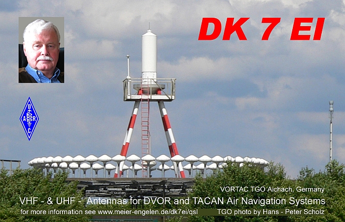
| Die Karte zeigt das Bild einer Antennenanlage für die Flugnavigation. Es ist die VORTAC Station "TANGO", die bei Aichach in Baden Württemberg steht. Diese Station umfasst eine Doppler VOR Anlage - der dient der untere Kreis von Antennen - und eine TACAN Anlage - dazu gehört die obere Antenne (der dicke Zylinder). VOR steht für "Very High Frequency Omnidirectional Range" und diese Station arbeitet nach dem Doppler Prinzip. Der Frequenzbe- reich solcher Stationen liegt zwischen 108 bis 118 MHz, also im VHF-Bereich. Mit dem Signal einer derartigen Station kann ein Flugzeug eine Kurslinie fliegen, mit Signalen von 2 Stationen seine Position bestimmen. Gegenüber den - einfacheren - VOR Stationen bietet eine Doppler VOR Station eine höhere Genauigkeit bei der Navigation. TACAN (Tactical Air Navigation) Systeme sind ursprünglich für die Navigation von Militärflugzeugen entwickelt worden, werden heute aber auch in der Zivilluftfahrt eingesetzt. Insbesondere die Entfernungsmessung zur Bodenstation über die DME (Distance Measuring Equipment) Einrichtung wird in Verbindung mit (D)VOR Anlagen genutzt. Dann reicht nämlich eine kombinierte VOR / TACAN Bodenstation zur Positions- bestimmung. TACAN nutzt den Frequenzbereich von 962 bis 1213 MHz, sendet also im UHF Bereich. Weitere Informationen zu VOR, DVOR und TACAN kann man im Wikipedia Lexikon nachlesen. Die folgenden Links führen zu den entsprechenden Beschreibungen der Systeme. Drehfunkfeuer VOR DVOR TACAN Navigationssystem
Warum habe ich das Foto einer VORTAC Station für meine QSL -Karte gewählt? Vy 73 de Egon, DK7EI
|
This QSL card shows the picture of an antenna system for aircraft navigation. It is the VORTAC station "TANGO" located near Aichach in Baden Wuerttemberg. This station consists of a Doppler VOR - utilizing the lower circle of antennas - and a TACAN system - which uses the upper antenna (the "fat" cylinder). VOR means "Very High Frequency Omnidirectional Range" and this station employs Doppler techniques. The operating frequencies for such stations lie between 108 and 118 MHz, thus in the VHF band. Making use of the signal of one said station an aircraft can fly a distinct course, using signals from two stations it can determine its position. In comparison with - simpler - VOR stations a Doppler VOR offers navigation with higher precision. TACAN (Tactical Air Navigation) systems originally were developed for military aircraft navigation, but today are also applied for civil aviation. Especially, the DME (Distance Measuring Equipment) feature yielding the distance to co-located (D)VOR- and TACAN ground stations is used in civil aviation. Then, the signals of one combined (D)VOR / TACAN installation are sufficient to locate an aircraft´s position. TACAN operates in the frequency range from 962 to 1213 MHz in the UHF band.
For further information on VOR, DVOR, and TACAN please visit the following pages on the internet:
Why did I choose the picture of a VORTAC station as the motive for my QSL card?
|